
The 'Friends' thought it might be a good idea to include some history about Sutton Common Recreation Ground (now Park) on our Website . This is a fairly light-hearted look at some of the recorded information, events, and memories of residents who live in the surrounding roads.
The first noteworthy comment about the park when talking to local residents is that
"It has always been there"
"Its so much part of everyday life that we look on the Park as ours, we walk through it, take children there to play, expect to hear (and sometimes object to) the noise of football"
and
"years ago there was ice-cream and teas for sale in the 'pavilion', and annual fetes, and cricket matches".
The second is the 1815 Sutton Parish map - Plot marked 'Churchwardens and Overseers of Sutton Parish'which coincides (other than land sold for houses in Sutton Common Road ) with the present Recreation Ground - but it was not possible to obtain a copy of the map. The following is from a freehand sketch superimposed on the 1913 Ordnance Survey map. The Sutton Local Studies people indicated that this land was part of 'the common'. Much of the surrounding land was marked 'Thomas Hatch Estate'.
The 1598/1601 Elizabethan Poor Law provided for a compulsory poor rate, 'Overseers of relief', with the Parish as the basic unit of Administration
At various times, including in Council Minutes, the park was known as 'Glebe' land
The dictionary describes ' glebe' as 'a piece of land yielding revenue to benefice'. Maps around 1850 and the Land Utilisation map of 1930 showed the land around this area as 'arable', and in 1842 the Parliamentary Gazette entry included:-
Chapter 1 p14 'Sutton Common Road in the Diocese of Winchester'
Tythe Map, 'Field No 27' (coincided with site of SCRG plus houses in SC Rd )
'Owner: Rector and Church Warden' (possibly the old St Nicholas)
'Occupier: the name of the occupier
'Arable: 18 Acres 0 Roods 8 Perches' and
'Tythe Payable: £5.18' (shillings).
Charles B Marshall's 'History of Sutton and Cheam' (1936) included on p101 under
'Open Spaces', 'Recreation Grounds' - 'Glebe Land' - Sutton Common Road (16 Acres), and under 'Earlier memorabilia' refers to 'Sutton, a parish in the Hundred of Wallington, Union of Epsom, a Rectory in the Arch Dioc. of Surrey and Dioc of Winchester'.
Other interesting information about the area surrounding the park includes
Robert P Smith's 'A History of Sutton ad 675-1960 under 'various items of interest'
Chapter IV p23 refers to 'Stone-cot Hill (the old Stane Street )' and that 'Sutton Common Road' existed in 1800.
1866 and 1895 Maps
Stonecot House is recorded on the 1866 map (on the corner where The Woodstock is now) (but on the 1895 map although the house still existed, the map showed only 'Woodstock' .
The 1866 map site of Sutton Common Road Recreation Ground was plot 31 (including the lower field reaching down to where Rutland Drive is now) but in 1895 was plot 252 (18.494 acres). Elm Farm was on the corner of Forest Road .
1926/7
In September 1926 the Sutton UDC Finance and Parliamentary Committee recommended a definitive offer of £4000 for the land now known as Sutton Common Recreation Ground
Legal Documents The deeds of this plot of land make very interesting reading, but it is not possible here to do other than pick out just a few of the more interesting items, including when and how the Urban District Council of Sutton purchased the site.
The Charity 'Poor's Land (Non-Ecclesiastical)' land
Charities in the Ancient parish of Sutton including a Charity known as 'Poor's land' were to be known as 'Non-ecclesiastical Charities'. The Charity was administered by 10 Trustees, including the Rectors of St Nicholas Sutton and All Saints Benhilton, persons residing or carrying on business in or near the Ancient Parish of Sutton, and representative Trustees appointed by the Urban District Council of Sutton.
The Trustees were to let/manage lands subject to the provisions of the Allotments Extension Act 1882 - land on Sutton Common - gross yearly income £17 14s 9d.
Established as 'Poor's Land Charity Scheme' on 4 July 1905 (under 1901 Act) it set out the heads under which income from the Charities might be spent.
The title confirmed 700ft (or thereabouts) on the north side of Sutton Common Road containing 18 ½ acres and numbered 252 on the 1913 OS Map.
The Charity was regulated by schemes of the Charities Commissioners of 31 August 1901 and 4 July 1905 related to The Charitable Trusts Acts 1853 to 1925, and the decision by the Trustees to sell for not less than £4000 was signed on 31 December 1926
February 1927 (SUDC Council Minutes) The consent of the Ministry of Health to the borrowing by the Council of £4000 for the purchase of this land, an application would be made to the Public Works Loan Board to lend the Council the money, to be repaid in 30 years.
The Contract dated 22 April 1927 between Trustees of the non-ecclesiastical Charities in the Ancient Parish of Sutton and The Sutton Urban District Council to sell and to buy for the sum of Four thousand pounds included reference to the sanction of the Ministry of Health to borrowing and the receipt of the money on loan from the Public Works Loan Board.
The property was to be sold subject to a 'Tithe Rent Charge' of Four guineas per annum payable to the Rector of Sutton, with about 16 acres let out on agricultural tenancies. The property was sold subject to the rights of the public to pass and repass across and over by two public footpaths. The rent of the tenancies was at the Rate of £3 per acre per annum.
Conveyance dated 23 August 1927 again refers to the 'rights of the public to pass and repass over the two footpaths (ie from now Rutland Drive towards the then Love Lane, and from now Elm Road West to now Morden Way) subject to such parts of the existing agricultural tenancies.
Later endorsements (difficult to read) related inter-alia to London Electricity Board sub station, and to 2.25 acres fronting Sutton Common Road

Extracts from Sutton & Cheam Council and Council Committee minutes
May 1927 - GPC considered acquisition of certain lands in the northern part of the town for use as open spaces and resolved the Clerk and Surveyor take immediate steps to enable the Council to pass the necessary resolution under the Town Planning Act.
October 1927 - application to M of Transport to raise classification of Sutton Common Road
January 1930 - reference to 'town' road to link Elm Road 'West' with Elm Road 'East' (now Romany Gardens)
January 1931 - decision to terminate 'allotment' tenancies - (still pursuing in March 1933)
February 1930 - an offer was made to buy, and in May 1930 a decision is recorded that 'Glebeland' was not for sale.
June 1932 - Tender accepted for 'levelling, drainage, and grass sowing (16 acres) (£300.15)' (Note - the change from 18 plus to 16 acres coincides with the land sold for houses fronting Sutton Common Road .)
- Entrance to 'Glebeland' from 'SCR reserved' when land fronting SCR sold
- SC & District Residents Association sought lease of land and erection of building
May 1933 - purchase of 'swings, rocking horses, and light swings' approved for 'Glebeland '
June 1933 - site considered for 'children's playground' and 'development of land between Elm Road (s) West and East for games'
June 1933 - Merton & Morden asked for 'contribution in respect of benefits to residents in that area'
Sept 1933 - complaints by residents of noise by children using swings - notices 'for use by children not exceeding 14 years of age' to be introduced - purchase of 'gates' authorised.
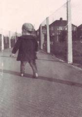
New path and fencing 1935 (photo: Geoff Kingate)
Piles Street Directory (1935 edition) mentions 'Entrance to Recreation Ground'
Pavilion costing £109 referred to in letter dated May 1936
Surrounding property
Houses were built in eg The Close in 1928 and in Hartland Way between 1930 and 1932.
'Soon after 1933 (see PS article at Appendix A), the area began to be developed. Stonecot House was demolished, houses were built opposite ours (in Sutton Common Road), Woodstock Rise, Chatham Close, Hilltop and the Woodstock public house was built. Then the many other developments the other side of Stonecot Hill were started and so the area became part of suburbia'.

Morden Way (unmade) 1935
Memories
Sutton Common 1933 - remembered
The 'Friends' first newsletter contained a delightful article by the late Peter Scott (a founder member) and this is reproduced at Appendix A. Peter wrote
'My first sights, when we arrived, were a nice back garden with fields behind (later the Recreation Ground). My excitement growing when I saw my first cows being walked from a farm in lower Morden Lane to be milked at a dairy in the shops by Forest Road'.
Ralph and Joyce write
Our memories from 1953 (when we moved to Hartland Way - a tree-lined road with a delightful well kept park), were made more vivid from the late 50's by the weekend football in the park area between Elm Road West and the pavilion. Starting early Saturday morning until mid afternoon - and again on Sundays - the 'game' commenced with the youngsters and with the older boys joining in until there were often more than 20 a side. Coats formed goalposts and the boys joined whichever side needed players. A large contingent came from around Hartland Way - there were some 24 children in Hartland Way alone.
The 'pavilion' was open at weekends and during afternoons for the sale of ice-creams and refreshments, three football pitches were in frequent use (one in the field joining Rutland Drive - now often referred to as 'the Paddock), and cricket at weekends in the summer. With three park-keepers - (including Nobby Clark, a favorite with our elder son), there was always one on duty to collect money for the tennis courts, and the grounds were always well tended; and there were huts for the park equipment and for the goalposts. The pitch and putt opposite the tennis courts was eventually used for additional car parking. Seems a bit odd, but the cricket boundary was eased to make way for the children's play area - but then cricket was too dangerous for other park users including the children.
We recall the air ambulance landing in the corner of the park in 1991 (a resident of Elm Road West had fallen through a garage roof) and that the pavilion and park-keepers huts were set on fire at least 3 times.
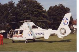
Air Ambulance in the park - 1991
Doris Oughton , who was for a time Secretary to the Sutton Common Horticultural and Allotment Society , produced newspaper cuttings around 1960/62, including photos, of the fete held on the Recreation Ground.
The Society held this major Summer fete each year on August Bank-holiday Monday, from the early 50's onwards, which was usually opened by the Mayor of Sutton. Apart from the usual activities including baby show, children's fancy dress, flower show, dog obedience, handicrafts, cookery, and pottery, there was for many years a model train ride.
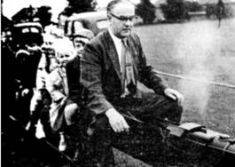
Model train rides - Summer Fete 1961
Geoff Kingate produced a photo of himself when about 2 years old which shows the new path and fencing on the Morden Way end of the park. He recalls about the war years when boys played football alongside the fence bordering on Morden Way and that from 1939 the park was planted and left to hay. There was a footpath from Elm Road West to the Sutton Common Road entrance - and boys would tie cottons across the footpath and hide in the hay to see passers by covered in cotton and hay. He also recalls the football and cricket, including the pitches in the lower field.
There was a land-mine in the lower field in 1942 - some 25ft in from the back of the houses in Morden Way ,which fortunately didn't explode, and that there was a British Restaurant in a temporary building on a bombed site in Sutton Common Road almost opposite the entrance to the park. He and his wife recall the Summer Fetes held in the park from the late 40s/early 50s.
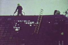
A keen photographer, he showed us a cine film of the fire which burnt down the Pavilion in 1976 and has provided a couple of 'stills' for our record.

He also provided the photo of Morden Way (unmade) in 1935.
It would be impossible to mention all who have helped with information, but thanks are due to:-
Sutton Library Local Studies help in searching maps, books, Council Minutes
Sutton Council Parks and Legal people
Southwark Local Studies Library
Eileen Scott (for Peter's article)
Geoff Kingate
Doris Oughton (Sutton Common Horticultural Society - former Secretary)
Ken Haagman
Pam Green who helped proof-read this article
Ref: FoSCRG 'History' October 2007 (Ralph Bunnage)
Sutton Common 1933 - remembered
I remember 1933 as the year we moved from a flat in Balham to a new semi detached house in Sutton Common Road . I can still see my mother's excitement at having a kitchenette, (so called by the Estate Agent) instead of a scullery and a real bathroom instead of the tin bath in the flat.
My first sights, when we arrived, were a nice back garden with fields behind (later the Recreation Ground). My excitement growing when I saw my first cows being walked from a farm in lower Morden Lane to be milked at a dairy in the shops by Forest Road.

I thought I was in paradise.
During the next few days we explored the area and opposite our house was a very large garden stretching from Gillian Park Road to Stonecot Hill and from Sutton Common Road to Ash Road . In this garden was a big house (Stonecot House) and a big lake (now filled in and used by the Sutton Model Engineering Club). The other side of Stonecot Hill was all fields and you could walk to Raynes Park crossing only a couple of minor roads.
Sir Alan Cobham brought his flying circus to these fields and we were allowed to get close to his planes including the famous 'Flying Flea'.

As I recall, only two families had cars, one belonging to our next door neighbour, a Dentist, whose surgery was the upstairs small bedroom, his main equipment being a foot operated treadle machine for drilling teeth and to this day I can still hear the screams and shouts of his patients.
Soon after, the area began to be developed. Stonecot House was demolished, houses were built opposite ours and Woodstock Rise, Chatham Close, Hilltop and the Woodstock public house were built. Then the many other developments the other side of Stonecot Hill were started and so the area became part of suburbia. Looking back I often wonder, in my old age, what life would be like today if Sutton Common Road and its surroundings had remained as I remember them, when I moved here in 1933. Happy Days?
Peter Scott
Memories of Morden Way and Sutton Common Park in the 1930s
My parents bought 89 Morden Way, a development of new semi-detached houses, in about 1930 or early 1931 when I was two-years old so I don't remember moving into it. The road was unmade at the time but I have memories of watching it being 'made-up' with lorries carting away the excavated soil and bricks, and men with long boards tamping down the new concrete, and others laying kerb stones. This was about the time I started school in September 1933.
Number 89 and its semi-detached partner number 91 were, and still are, on the outside of the bend at the lower end of Morden Way, and as the bottom boundary of the back gardens in the road ran straight we had two of the longest gardens in the road. The bottom end bordered on Rutland Drive, and the bottom of our garden was the dividing line between Sutton and Morden council areas. My Dad put a gate in the bottom of the garden to make it a shorter walk to Epsom Road and buses to Morden.
The bottom of our garden was also at the corner of a field which, together with a larger field running up to Sutton Common Road, was bought by Sutton Council as a recreation area. The smaller bottom field and the larger top field were divided by a footpath, later fenced off, running from Morden Way opposite Romany Gardens, formerly Elm Road East, to Elm Road West which led to Epsom Road. The two fields were generally called the 'top rec' and the 'bottom rec'.
The top rec was developed with a cricket pitch, a bowling green, tennis courts and a pavilion which sold drinks, ice cream and so on. The cricket pitch was in use almost every weekend and children were told not to wander on to the main part of the rec in case they were hit by a cricket ball. If we wanted to go to the pavilion to buy an ice cream we had to walk along the footpath to the Elm Road West end and up another footpath to the pavilion. Together with the other children from the lower part of Morden Way I regarded the top rec as being made for adults to enjoy, not for children to play, so we used to spend a lot of time in the bottom rec which, apart from being mowed by a tractor pulling ganged mowers several times a year, was left undeveloped.
The two recreation grounds were by this time fenced off by heavy chain link fencing fixed to concrete posts but there was no entrance to the bottom rec from Rutland Drive, an omission which I see from internet maps has since been rectified. To save walking halfway up Morden Way to get to the bottom rec I and other children from the lower part of Morden Way used to walk through our back garden into Rutland Drive and climb over the wire fence.
That wouldn't be possible now, entrance or not, as I see from satellite pictures on the internet that the long back gardens of 89 and 91 Morden Way are no longer long. The lower parts have been divided off and seem to have been sold for development as there are now houses on the site.
We moved from Morden Way early in 1939, so I have no memories of the area during wartime.
Peter Wallage
Memories of Sutton Common Park and surrounding area - Alan Cross July 2013
The Park. I was knocked sideways by the photo taken in 1935 by Geoff Kingate of the new path and fencing. About a year after he took that photo I was presented with my two-wheeler fairy cycle painted blue. In those days stabilisers for fairy cycles had not been invented. I lived at 1 Litchfield Avenue, and like a fledgling bird having to learn to fly from the nest, I ventured out wheeling my new cycle with no idea of how to ride it. Mum suggested I did a trial run on that very pathway in the photo. I survived upright for several yards along the path and at a point just past the entrance to Hartland Way crashed violently into the fencing. The scratches and pain inflicted by that fence are remembered as vividly today as they were some 77 years ago. Thank you so much for that photo, which I think was taken a little further on from the scene of my mishap.
Land-mines.
I am not sure about an unexploded land-mine in the lower field mentioned in the SCP History. There was an unexploded land-mine in the area. It was one of two which floated down one night. One landed and exploded on the St. Helier Estate on the other side of the railway embankment. It caused widespread damage, particularly to Glastonbury Road and the surrounding area. A few days afterwards I went over to see the devastation, and it was horrendous. But for the railway embankment the houses in the Morden Way area would have been seriously damaged by the blast from that land-mine.
The second mine I know of did not explode. It had landed behind Rutland Drive , close to the little bridge over the Pyl Brook stream on the footpath which led diagonally over the allotments to Holne Chase. If that one had exploded the destruction in Rutland Drive and surrounding streets would also have been horrendous. Early the following morning after its discovery everybody in all the houses between there and as far as the London/Epsom main road were told to leave as quickly as possible and make their way to a safe place. This happened to be down Lower Morden Lane, then all the way down Grand Drive almost as far as Bushey Road, to the church hall adjacent to the church on the left hand side of Grand Drive This had to be undertaken on foot, and it was a long, long walk from Litchfield Avenue to the church hall. At last, towards evening, it was announced the mine had been defused and it was safe to return home. A day or two later my big brother came in clutching a piece of silk fabric from the parachute.
Bowling Green . I am sure someone has recorded the fact that the green had a direct hit from a bomb. It made a huge hole with earth flung all over the place. Fortunately the blast from it was not quite so severe because of the depth of the crater. (see Friends Note at end) Houses backing on to it in Sutton Common Road were never the less very severely damaged. Our house in Litchfield Avenue only suffered a cracked window, and it was from "Fisher's Yard" (see under Hartland Way ) that Father obtained the pane of glass to replace the cracked one.
The floor shook as we sheltered in our Morrison shelter, which had been installed in the front room. I was allowed to chalk out roads on the 1/4 inch steel table top and play "buses" on it with my models
Hartland Way or Rustington Walk?. I was told an oil bomb had landed in someone's front garden. I went to have a look but cannot be sure now which of these roads it was. There was a house about half way down on the lower field side of the road with black soot scorch marks all up the wall of the downstairs front room, but the house did not appear to have been damaged.
Older residents will probably recall with nostalgia the firm of E. S. Fisher & Son who had a wonderful hardware shop in the parade of shops up at the Woodstock, in the block with the undertakers, Fredk. W Payne. It had wooden floors and the wonderful smell that hardware shops had at that time. On the opposite side of the road they had a timber yard (now occupied by maisonettes) There was also a newsagents and tobacconists named "Bruce's, close to E.S. Fisher & Sons. In the early 30s he produced a pack of six postcards (including Sutton Common Road, Litchfield Avenue and Hartland Way) illustrating local streets which had been recently built, probably with the hope that proud new owners would buy them to send views of "their road" to friends.

The photo of Hartland Way in the early 1930s from the Park entrance
Farther afield.
There were at least two anti-aircraft guns located just inside the London Road entrance to Morden Park on the right-hand side. They made a terrific racket when fired. After a short period one heard the crump of the shells exploding, and again, on occasions, the soft tinkling sound of shrapnel on the tiles of our tiles. This always happened at night, as there were not many daylight raids at that time. In the morning the roads were scoured for bits of shrapnel. A lot of kids did this and we sometimes exchanged pieces with each other at school. I still have a biscuit tin full of shrapnel. (Would make a splendid door-stop if anyone is interested )
Sutton Common 1933.
The Sutton Creameries bottling plant was situated close to Sutton Green on the Sutton side (behind where the 654 trolleybus terminated). The farm with the cows was "Lower Morden Farm". Now a school occupies the site. In the early '30s there were no houses on the left hand side of Lower Morden Lane and Mum would push me along in my push chair down this leafy lane which on reaching the farm opened out with a green and pond on the left and the farm on the right. The black-pitched wooden cow shed, which on a sunny day seemed very dark inside, gave off that wonderful farmyard aroma and one had to tread with care. Sometimes we would turn into the pathway beside the farm which eventually followed the boundary of Morden Park up the back of Hillcross Avenue , and Mum would complete the round trip by following a path off to the right that brought us on to the London Road . At other times the walk was down to the cemetary gates and back. The cows at the farm grazed on the huge open space on the right of the road leading to the Battersea New Cemetary entrance
The milkman delivered our milk from a three wheeled Sutton Creameries handcart painted cream with red lettering. During the war I had the task of collecting the weekly butter ration of 8ozs from the Sutton Creameries and walked through the Rec. to get it. Another Sutton firm also delivered down our road before the war. "Dendy Napper" delivered bread over a wide area by horse and cart. The horse regularly stopped outside 1 Litchfield and fed on the grass verge.
There was a pig bin situated on the corner of Woodstock Avenue and Elm Road during the war. This emitted quite a pungent aroma in hot summer months. The bin was like a normal dustbin, perhaps a bit larger, with a lid, and we were encouraged to put our vegetable scraps in it for pig food.
Local Buses. Older residents may just remember in 1940-1 seeing buses of another colour than London Transport red passing along London Road and Epsom Road . This was during the period that many provincial bus operators loaned buses to London to help cover shortages in the London fleet arising from the London blitz. On our local routes for a brief period could be seen buses from Birmingham City Transport (blue and cream), Hants & Dorset Motor Services, Southampton (Green), Hull Corporation (blue and white) and Manchester Corpn. (an orangy/red red and cream). The latter worked on the 127 route (Morden South Wimbledon via Worcester Park), and I used to go to my school in Worcester Park on these.
![]()
Litchfield Avenue . was part of a large estate of nearly identical semi-detached houses. As built they did not have garages, but did have space each side. Exceptions were at the far end of Rutland Drive where there were terraces of four ? (or six?) houses. The other odd ones out were Nos. 1 and 2 Litchfield Avenue which were detached. I understood my Father to say that for nos. 1 and 2 the purchasers were given the choice of a built on garage with a room above, or a built on garage with a storage room above. No. 1 cost £1,050 new. In 1951 he proudly announced that at last he had paid off the mortgage and the house was ours. When he moved out in 1977 the house was in dire need of modernisation. As built there was only one 15amp power point (for electric fires) in the hall and one on the landing; there was also one in the kitchen. I am not sure who built this estate (was it Crouch?).
Alan Cross, July 2013
Friends Note The Sutton Local Studies Library provided the following information about bomb incidents in the vicinity of the Recreation Ground
1 Extract from Details of Bombs and Craters, Field Book Record
by Fred Darbyshire, Engineering Assistant, Borough of Sutton & Cheam
2 Google map marking bombs dropped on the Sutton & Cheam Borough throughout WW2
3 Extract and Google map information:-
*403/405 Sutton Common Rd, direct hit High explosive, 10 Nov 1940, 6.37pm (Opposite side to the park entrance see Geoff Kingate re the site of the British Restaurant))
*Sutton Common Recreation Ground, bowling green High explosive, 25 Sep 1940 , 9.50pm ( Crater 14 foot diameter by 7 foot deep.)
*45/47 Morden Way, direct hit High explosive, 10 Oct 1940, 8.25pm
*Morden Way, allotment at rear Unexploded anti-aircraft shell, 24 Feb 1944, cleared 21 May 1944
It has not been possible to research bombs, landmines, V1s and V2s in London to complete the picture